Specific Protection Plan of Gansu Dunhuang Yardang National Geopark

I. Recent plan (2013-2015)
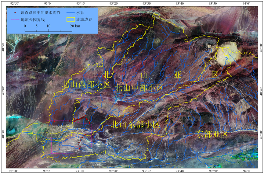
1. The scope of the external buffer area of Geopark is expanded. It is recommended that upwind area and mass flow area of flood in protected area are included in the buffer area of the scenic spots. See Figure 1.
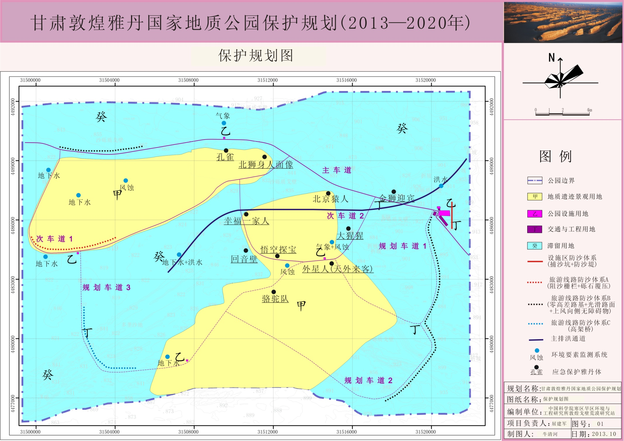
Tour routes within the buffer area are planned, particularly the driven routes of motor vehicles. It is avoided that motor vehicles roll freely and destroy the primitive surface of Gobi. The dust emission is increased. The abrasive effect on Yardang is enhanced; no free mining, dredging and soil unloading and dumping of garbage in the buffer area and the flood channels will be avoided to be blocked.

Figure 1 Borders of buffer area in Geopark (with watershed boundary as the criterion)
2. The sand prevention and control system of infrastructure is established in the Geopark.
(1) Sand prevention and control of solar energy and wind power plants and parking lots in the Geopark. Next to the east side of solar energy and wind power plants and parking lots, two north-south sandpits (2 meters deep, 2 meters wide, 300~500 meters long, with interval of 5 meters) are excavated. The excavated earthwork is used to respectively establish two sand-control dams in eastern side of the sandpits. See Figure 2. The wind-drift sand from the eastern Gobi is effectively prevented. The chance is reduced that solar energy and wind power plants and parking lots are grinded and eroded by accumulated sand and wind-sand.
Sand-control dam Gobi

Figure 2 The longitudinal section of the sand prevention system of infrastructure in the east of the Geopark
(2) Sand prevention and control of roads in scenic spots. Sand prevention and control of roads in scenic spots is unlike that of other traffic routes. In the meanwhile of the consideration of the effect of sand prevention, it should also be coordinated with the overall landscape in scenic spots. The main sand movement within the scenic area mostly takes the form of Gobi wind-sand flow. Only when an obstacle is encountered, sand accumulation will appear in the front and rear of the obstacle. If no obstacle, accumulated-sand hazards will not be produced. Thus, it is recommended that roads in scenic spots keep as smooth as possible. The roadbed should not be too high. It had better be the roadbed with zero altitude difference. Such roadbed is as high as upwind lateral ground. It thus plays a role of leading and filtering sand. It is inappropriate that there exists an obstacle near the two sides of road (within 20 meters), especially upwind side. Thus, accumulated sand on the road can effectively be avoided, such as the main road. Such sand prevention system can be implemented on planned lane 1 and planned lane 2. In addition to the Gobi wind-sand flow above, near the downwind side of Yardang, fan-shaped gravel mound occurs because of flow divergence, low wind speed and accumulation of sand gravels. Even the situation happens that the roads are buried by gravel mound. The road should be more than 200m away from the downwind side of Yardang body. These gravel mounds shall be avoided to the greatest extent. For some areas that can not be avoided, such as the southwest section of secondary lanes, the sand prevention system with resistance and consolidation combined shall be employed. That is, vertical sand-blocking fences shall be established about 500 meters away from the upwind side of the road. 50-meter-wide empty zone shall be set behind the fence. The method of sand consolidated by covered and pressed gravels is adopted between the empty zone and embankment. Accumulated sand on roads is effectively curbed. It is unsuitable to build a large area of sand prevention facilities at the upwind side for the southwest section of planned lane 3 through the dune area. Reason is that it goes through the moving dune areas, with the effect of the landscape taken into account. It is appropriate to go through the dune areas by way of viaduct. In the meanwhile when the accumulated sand on the road is avoided, viaduct can serve as the viewing deck of the landscape in dune areas.
(3) Protective measures of the signs and road milestones in the scenic spots are implemented. Mainly through weather-resistant surface-spraying of the signs and road milestones in the scenic spots and sand- grinded chemical materials, its service life is prolonged.
3. The protection of fine Yardang body
(1) The separate periphery protection area is set up for fine Yardang body. Within Yardang group, the length of the upwind side of protected areas can not be shorter than 20 meters. The other sides can not be shorter than 10 meters; for the appearance of Yardang group, the length of upwind side of protected area must not be shorter than 50 meters. The other sides can not be shorter than 20 meters. Guiding-sand wall is set up on the upwind if necessary. Within periphery protection zone, tourists are prohibited from entering. The ground remains pristine.
(2) At both sides of fine Yardang body near flood channel, flood channels should be set. Thus, fine Yardang body is avoided being eroded and soaked by flood.
(3) Emergency protection of fine Yardang body. Artificial chemical strengthening program is preferably chosen. Chemical strengthening measures are taken. The fine Yardang body is protected. Preferable artificial chemical strengthening program takes the following three steps. First, the physical and chemical properties of Yardang body are analyzed. The domestic and international mainstream reinforcing materials are then used to interiorly reinforce standard samples. Such properties as water resistance, freeze-thaw resistance and anti-erosion of the samples after reinforcement are tested. Reinforcement material formulation is optimized and designed. Data in laboratory is obtained. Besides, the Yardang-like body is selected for reinforcement. In the case of ensuring no damage to fine Yardang body, Yardang-like body in similar environment of fine Yardang body is chosen to carry out field reinforcement experiment. With artificial acceleration, the experiments are ruined in the simulated natural environments of the wild. Mainly including experiments of water erosion and wind erosion, data of field test are obtained; and finally, with how self-developed reinforcement materials and domestic and international mainstream reinforcement materials are shown in the laboratory and field experiments, reinforcement materials and methods are selected. They are suitable for the protection of classic Yardang body. Part of the fine Yardang bodies is reinforced and protected.
4. Publicity and education are improved. Men are prohibited from climbing Yardang body. The content of environmental education that climbing is forbidden is added to popular science film of the scenic spots. Meanwhile, warning signs are set in the eye-catching places and the surrounding area of fine Yardang bodies. Men-climbing and destruction shall be avoided. Or it will accelerate the declining process of Yardang landform.
5. The funding for basic and applied research in the Geopark is increased. The sand monitoring system is enhanced. Flooding and groundwater monitoring systems and erosion monitoring system of Yardang body are additionally set up. Basic data are accumulated for future optimization and design of protection scheme.
II. Long-term plan (2016-2020)
1. Construction of flood control facilities. According to flood monitoring data of early days, the existing northeast-southwest natural flood channels in the center of Yardang Geopark is transformed. It is proposed that artificial flood channel shall be designed to withstand once-in-a-century flood attack. Meanwhile, fine Yardang body and concentrated area of Yardang body shall be avoided and bypassed.
2. Anti-seismic and anti-collapse reinforcement. For dangling area and fissures of some fine Yardang bodies, sophisticated reinforcement technology is utilized to conserve the remains. The collapse and the expansion of cracks under other external force will be avoided.
3. Prevention of groundwater intrusion. With the implementation of "the Project of leading water of Haerteng Rive to Dang River", the rapid rise in regional groundwater level, especially in the groundwater level of wetlands of West Lake, will inevitably lead to the rise in the groundwater level of Yardang Geopark. It plays a certain destructive role in the Yardang landform. The measures to prevent groundwater intrusion need to be implemented.
4. Regional sand prevention and control system is improved and optimized. Emergency protection programs of fine Yardang body shall be optimized and expanded.

 简体中文
简体中文
